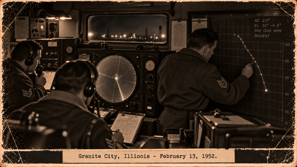
A radar crew plots a descending target at Granite City, February 13, 1952.
THINK ABOUTIT UFO|UAP SIGHTINGS REPORT
1952: A Radar Bomb-Scoring Crew Plots a Target Dropping at 1,090 mph, and ATIC Blames the Radar
At about 10:30 p.m. on February 13, 1952, a radar bomb-scoring detachment at the Granite City Engineer Depot, Illinois, was tracking aircraft 8095 on a practice run for the 97th Bomb Wing when the target on its scope began to do something no bomber does. Forty miles out it was locked in automatic tracking, with an altitude readout of 48,000 feet. At about twenty miles it sped up, turned to 197 degrees and began to descend.
When the plotting equipment settled, the target was five miles west of the site and its ground speed measured 924, 888, 840, 804 and 744 miles per hour in successive five-second intervals; the crew estimated about 1,090 mph along its descent. Moments later radar contact resumed on a target heading east at about 30,000 feet. The unit’s adjutant sent the report to Strategic Air Command, and in June 1953 ATIC wrote that the equipment had probably malfunctioned. This Granite City, Illinois radar UFO case is a good example of how Blue Book handled a radar target that behaved normally until it did not.
Date: February 13, 1952
Sighting Time: About 2230 CST
Day/Night: Night
Location: Granite City Engineer Depot, Granite City, Illinois (38.73°N, 90.14°W); the target approached from the Jacksonville, Illinois IP and descended west of the site toward the St. Louis area
Urban or Rural: Industrial depot near the St. Louis metropolitan area
No. of Entity’s: Not Applicable
Entity Type: Not Applicable
Entity Description: Not Applicable
Hynek Classification: RV (Radar; no visual contact reported)
Duration: About 25 seconds of plotted descent on the expanded scale; the whole run took several minutes
No. of Object(s): 1 on the scope; no second target described
Description of the Object(s): Radar return only. It tracked normally as the bomber on its scoring run, then behaved differently from about 20 miles out.
Shape/Size/Color of Object(s): Not Applicable (radar return only)
Distance to Object(s): Contact from about 75 miles; automatic tracking at about 40 miles; speed and turn at about 20 miles; plotted descent began about 5 miles west of the site
Height & Speed: Cleared at 29,000 feet pressure altitude; automatic-tracking altitude read 48,000 feet with a doubler control, which the crew assumed was a faulty doubler circuit; plotted ground speeds 924, 888, 840, 804 and 744 mph at five-second intervals; the crew estimated about 1,090 mph along the descent; level again at about 30,000 feet heading east
Number of Witnesses: The radar crew of Detachment 4, 3903d Radar Bomb Scoring Group, and the aircrew of aircraft 8095
Special Features/Characteristics: Normal range and azimuth until 20 miles out; speed-up, turn to 197° and descent at that point; gradual drift to about 200° during the last ten seconds of the plot; immediate equipment checks reported the radar operating normally; the 30,000-foot wind was about 70 mph from 260°
Case Status: Blue Book lists it as Other (radar malfunction) and Insufficient Data. ATIC wrote on June 3, 1953 that the case could not be firmly evaluated, but that radar malfunction was very likely, and that a temperature inversion and moisture lapse may have produced anomalous returns
Source: 3903d RBS Group letter to CG, SAC of February 19, 1952 (signed by the adjutant); ATIC comment of June 3, 1953 on “Unidentified Radar Returns”; Blue Book list; Sparks #359; McDonald list
Summary/Description: An RBS crew tracked a target that behaved like the cleared bomber until 20 miles out, then sped up, turned and descended to an estimated 1,090 mph before levelling at about 30,000 feet. ATIC judged radar malfunction likely.
Related Cases: Antung B-29 cylinder (February 24, 1952); Nenana radar intercept (January 22, 1952); February 1952 archive
Detailed Report
The report is a letter dated February 19, 1952 from Headquarters, 3903d Radar Bomb Scoring Group, Carswell AFB, to the Commanding General, SAC, giving the “known facts” about an unidentified target tracked by Detachment 4 on the night of February 13 during the evaluation mission time scheduled for the 97th Bombardment Wing.
Aircraft 8095 was cleared from the Jacksonville, Illinois IP at a pressure altitude of 29,000 feet, about 75 miles from the RBS site, on a true course of 180° at about 2230 CST. Ground radar contact was established with a target over the IP; its range and azimuth looked normal, the elevation angle in mils approximated the bomber’s altitude, and the approach was as reported by the cleared aircraft.
The target was locked in automatic tracking at about 40 miles from the site. An altitude check was then possible: the doubler control in the altitude circuit read 48,000 feet. Because the target’s progress up to that point looked normal, the crew assumed the X-2 altitude doubler circuit was inoperative. The target continued at normal ground speed and heading until about 20 miles from the site, apart from the questionable altitude readings.
At about 20 miles the target increased its speed, turned to a new heading of about 197° and began descending. The plotting equipment was switched from map scale (1:250,000) to plotting scale (800 yards per inch), and when it settled the target was plotted at a horizontal range of about five miles west of the site. In the expanded scale the horizontal ground tracks measured speeds during five-second intervals of 924, 888, 840, 804 and 744 miles per hour. The target held about 197° for the first fifteen seconds and drifted to about 200° in the last ten. After the plot, radar contact was made again with the target heading east at about 30,000 feet, approximating the altitude of the aircraft using the RBS site.
Immediate checks found the RBS equipment operating normally, so the crew said the incident could not be credited to the ground radar. They estimated the target’s speed at about 1,090 mph during its plotted descent, when the horizontal component read 924 mph. The letter then offers its own explanation: that the target was an aircraft pacing the bomber on its run, which at about twenty miles banked and descended across St. Louis, began pulling out of its descent while decelerating, and banked west for a new level heading. It notes that no wind data were available at the site for the extreme altitude, but the 30,000-foot air movement was about 70 mph from 260°.
A Blue Book cover note asked a reviewing office for an opinion of this and a Carswell AFB case of February 13, 1953, and asked whether a moisture inversion can affect radar as a temperature inversion does. ATIC’s reply of June 3, 1953 says the incident cannot be firmly evaluated. Since the target appeared normal until the plotting equipment was switched to the expanded scale for 25 seconds, it appears very likely there was some malfunctioning of the radar, although the report says immediate checks found the tracker operating normally. The reply adds that the radar data are insufficient for analysis, that there was no indication the targets seen on the APG-41 radar were moving targets, and that the submitted weather data show a temperature inversion and moisture lapse around the time that could cause ground-clutter signals to appear above the horizon.
RESEARCHER’S NOTES
Normal Until It Wasn’t, and Then Explained Away
- A Different Kind of Radar Case. Granite City is a radar bomb-scoring set tracking a known bomber, so a stray echo or altitude error would affect the scoring itself. That makes the crew’s report unusually concrete, and also gives the 1953 review a specific failure mode to look at.
- The Altitude Readout. The 48,000-foot reading came from a doubler control the crew themselves assumed was inoperative. If the doubler was working, 48,000 feet would be far above the bomber at 29,000. If it was not, the descent figures lose their vertical component. The report does not say which.
- The 1,090 mph Estimate. Only the 924-mph horizontal component is a measured figure; 1,090 mph is the crew’s estimate of speed along the descent. Later speeds in the series fall to 744 mph, so the target was decelerating during the plot.
- The Pacing-Aircraft Explanation. The SAC letter itself proposed an aircraft descending after pacing the bomber, which would require a very fast, high-altitude descent, a diving turn across the St. Louis area and an almost immediate level-off. The file shows no check of civil or military traffic.
- ATIC’s Malfunction Call. The 1953 comment is cautious: “very likely” a malfunction, an unresolved weather inversion, and no further data to obtain. Blue Book’s own list carries it as both Other and Insufficient Data, so it is not a BBU.
- Hynek Class. Hynek’s original system has no radar-only category; RV is the closest fit and is used because radar was the only evidence.
The Granite City report is a bomb-scoring crew documenting a target that matched a bomber until twenty miles out and then did not, in a letter signed by a unit adjutant and sent to SAC. It is useful less as a mystery than as a case study: the primary report, the crew’s own explanation, and ATIC’s later radar-malfunction review all sit in one file, and none of them closes the gap between a normal track and a 1,090-mph descent.
“It is estimated that the ‘target’ was traveling at about a speed of 1,090 miles per hour during its plotted descent.”
— 3903d Radar Bomb Scoring Group, report to SAC, February 19, 1952